Skip to content
The UK May snow forecast is trending because weather maps and media reports are showing a sudden cold spell, possible wintry showers and snow risk in parts of the UK during mid-May 2026.
The official Met Office UK forecast, updated on 11 May 2026, says the week from Monday 11 May to Friday 15 May will bring sunny spells, showers at times and rather chilly conditions. It also mentions below-average temperatures, a brisk northerly breeze, heavy showers on Wednesday and Thursday, and a risk of overnight frost.
Netweather also reports an unseasonably cool week, with Arctic air moving south from midweek, widespread showers, hail and thunder, and possible snow over the Scottish mountains.
This does not mean the whole UK will see snow. The highest snow risk is over Scotland, especially higher ground, while parts of northern England may see cold rain, hail or wintry showers depending on elevation.
London is forecast to stay chilly rather than snowy, with highs around 13–16°C during the middle of the week and showers at times.
For UK homes, the practical concern is wet shoes, damp entrances, muddy carpets, cold draughts, condensation and slower drying after showers.
UK May Snow Forecast 2026: Latest Update
The UK May snow forecast has gained attention because several weather-map headlines point to a short but sharp change in conditions. After warmer spells earlier in May, the UK is now moving into a colder northerly or northwesterly pattern.
The Met Office forecast for 11–15 May says temperatures will be below average for most areas. Rain moves southwards at times, northern Scotland and eastern English coasts see showers, and a rural frost is possible overnight where skies clear. Tuesday stays chilly, especially in the brisk northerly breeze. Wednesday and Thursday become blustery, with sunny spells and heavy showers. Friday turns more settled, but the chilly feel and overnight frost risk remain.
Netweather gives more detail on the cold source. It says Arctic air will arrive from midweek, with widespread heavy showers, hail and thunder. It also says snow is possible on Scottish mountains, while temperatures reach only around 11–14°C in many areas on Thursday.
The key point for UK readers is this: May snow is possible, but mainly in northern and higher areas. Lowland snow is much less certain.
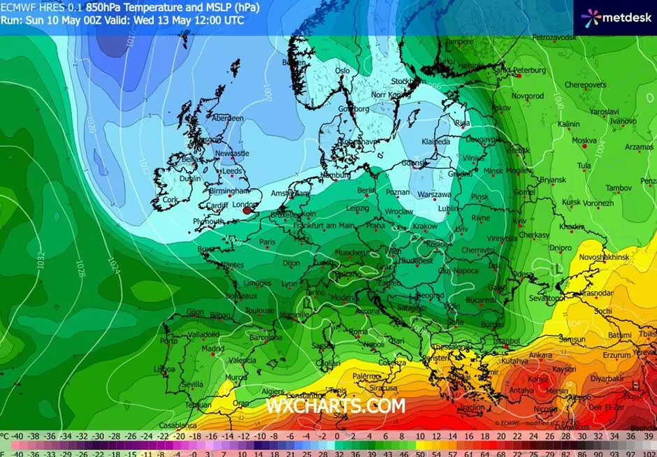
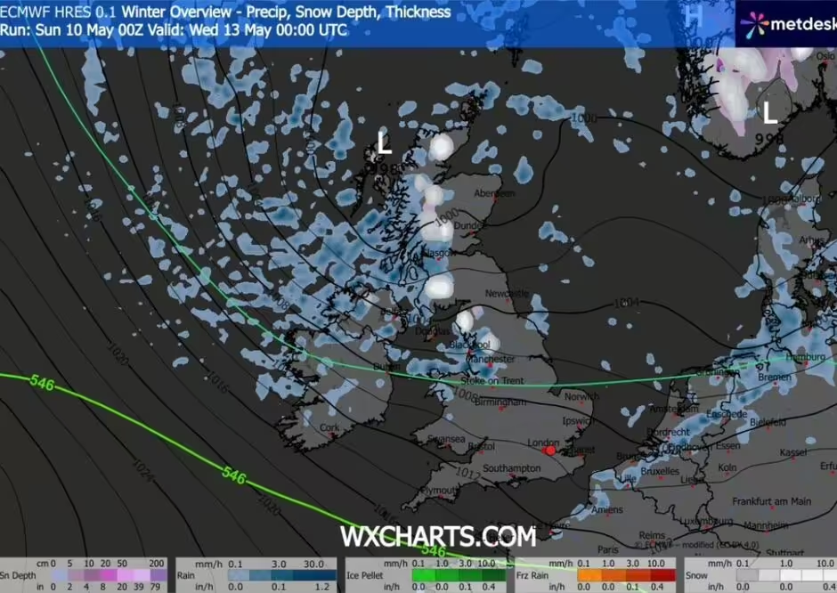
Weather Maps Showing Snow: What They Mean
Searches such as “UK snow weather maps”, “UK weather maps show 30 hours of snow” and “snow forecast UK” are linked to model-based weather maps. These maps show possible precipitation type, snow depth, freezing levels and air mass movement.
Some headlines are reporting around 30 hours of possible snow affecting parts of England and Scotland, with 13 counties mentioned in weather-map coverage. Ground News summarised the story as a wintry May forecast affecting 13 UK counties over around 30 hours.
But weather maps need careful reading. A map showing snow colours does not always mean snow will settle at street level. In May, the sun is stronger, ground temperatures are usually higher, and showers can fall as rain, sleet, hail or wet snow depending on local elevation and timing.
A map can show snow risk over:
- Scottish mountains
- Highland routes
- The Grampians
- Pennine high ground
- Northern hills
- Exposed rural areas
- Higher parts of northern England
It does not automatically mean major lowland disruption.
Official Met Office Forecast: 11 May to 15 May 2026
| Date | Official UK Outlook | Main Weather Risk | Snow Relevance |
|---|---|---|---|
| Mon 11 May | Cloud and patchy rain moving south, sunny spells elsewhere | Chilly feel, showers north/east | Very low for most areas |
| Mon night | Rain moves southeast across Scotland and Northern Ireland | Rural frost in clearer areas | Cold enough for frost, not widespread snow |
| Tue 12 May | Rain in the north clears south, sunny spells follow | Brisk northerly breeze | Higher ground may feel wintry |
| Wed 13 May | Blustery, sunny spells, heavy showers | Hail, thunder, cold air | Scotland/high ground snow risk higher |
| Thu 14 May | Heavy showers continue, chilly | Hail, thunder, frost risk later | Scottish mountains most likely |
| Fri 15 May | Drier, brighter and more settled | Chilly night, frost risk | Snow risk reduces for most areas |
The Met Office long-range forecast for 15–24 May says changeable and rather unsettled weather is likely to dominate, with rain or showers, some heavy, and temperatures close to or a little below normal. Later in May, from 25 May into early June, more settled weather becomes more likely, with longer dry spells and temperatures recovering closer to average, possibly warm at times.
Scotland Snow Forecast
Scotland has the clearest snow signal in this cold spell. The main risk is not a widespread lowland snow event. It is more likely to be snow over mountains and higher routes, with wintry showers possible in colder air.
Netweather says the air later in the week will have originated from within the Arctic Circle and that snow is possible on Scottish mountains. It also mentions widespread frost risk at night where skies clear.
Edinburgh’s 7-day forecast shows a cool pattern rather than a major snow signal: highs around 11–15°C between 11 and 17 May, with showers at times and overnight lows near 4–7°C.
Higher parts of Scotland may feel much colder than cities. Mountain routes, rural roads and exposed areas should be checked through official local forecasts before travel.
Northern England and Manchester Weather
Northern England may feel the cold spell more strongly than southern England, especially in the Pennines and higher ground.
Manchester’s forecast shows a cool week, with highs around 11–14°C through the middle of the week and showers in places. Wednesday and Thursday look particularly cool, with daytime highs around 11°C.
For most urban areas in northern England, cold rain, hail or showers are more likely than lying snow. Higher ground can still see a wintry mix when colder air moves south.
Areas to watch include:
- Pennine routes
- Cumbria high ground
- Northumberland hills
- County Durham high ground
- North Yorkshire hills
- Exposed rural roads
- Elevated areas near the Scottish border
London Weather: Chilly, But Not a Snow Story
London is part of the colder UK trend, but it is not the main snow-risk area.
The London forecast for 11–17 May shows cloudy or partly cloudy conditions, showers at times, and highs generally around 13–16°C, rising closer to 18°C by Sunday 17 May. Overnight lows sit around 5–10°C.
That means London should expect a cool, showery mid-May feel, not a realistic snow event at city level. The practical issues for London homes are more likely to be:
- Wet shoes
- Damp hallway carpets
- Muddy entrances
- Slow drying after rain
- Condensation in cooler rooms
- Pollen and dust trapped in carpets between showers
UK Temperature Drop: Why It Feels Cold for May
The sudden cold feel comes from air moving down from the north. Netweather describes a cool northerly or northwesterly flow, with Arctic air arriving midweek. This pulls temperatures below the normal feel for early to mid-May and creates showers, hail, thunder and overnight frost risk.
The Met Office also says temperatures are below average for most areas and that the week remains chilly with frost risk.
This is why people are searching:
- UK temperatures plummet Wednesday
- UK May cold weather
- UK weather forecast
- weather forecast Met Office
- snow in Scotland
- Scotland snow
- temperature
The strongest cold feel is likely in the wind, especially in northern and eastern areas. Even where daytime temperatures reach double figures, a brisk northerly wind can make it feel much colder.
UK Regions Most Affected by the Cold Spell
| Region | Expected Weather | Snow Risk Level | Practical Note |
|---|---|---|---|
| Scottish Highlands | Cold, showers, mountain snow possible | Higher | Check mountain and road forecasts |
| Central Scotland | Cool, showers, frost risk | Moderate on high ground | Urban snow less likely |
| North East England | Breezy, showers, chilly | Low to moderate on hills | Hail or wintry showers possible |
| North West England | Cool, showers at times | Low to moderate on high ground | Pennine areas colder |
| Yorkshire | Showery, chilly | Low to moderate on higher routes | Hill snow risk depends on elevation |
| Midlands | Chilly, showers possible | Low | Frost possible in rural spots |
| Wales | Cool, mixed showers | Low on high ground | Wet and chilly rather than snowy |
| South West England | Chilly, then some drier spells | Very low | Mostly rain/showers |
| London & South East | Cool, showers, cloudy spells | Very low | No main snow signal |
| Northern Ireland | Rain moving southeast, chilly | Low | Frost risk under clearer skies |
Weather Maps vs Met Office Warnings
Weather maps and public weather warnings are not the same.
Weather maps show model possibilities. They can be useful for spotting patterns, but they change as new data arrives.
Met Office warnings are impact-based. They are issued when weather is expected to cause disruption or risk. The Met Office warning page explains that yellow, amber and red warnings relate to possible impacts, not only the weather type.
At the time of the Met Office warning page checked on 11 May 2026, the listing showed no UK warnings for Monday 11, Tuesday 12 or Wednesday 13 May.
That means the current official picture is a cold, showery and frosty week, with snow risk mainly in northern high ground, rather than a confirmed UK-wide snow warning.
Travel and Home Planning During the Cold Week
For travel, the main concern is not only snow. Showers, hail, wet roads, gusty winds and frost can still affect journeys.
Drivers in Scotland and northern England should check local forecasts if travelling over high ground. Rural roads can feel much colder than city centres. Early mornings may bring frost in exposed areas.
For homes, the cold spell can affect comfort and cleaning in small but real ways:
- Damp shoes can mark carpets near doors
- Pets may bring wet paws indoors
- Hallway rugs can hold moisture
- Cold rooms can dry more slowly
- Upholstery can hold a damp smell if ventilation is poor
- Muddy entrance areas can spread into living rooms
For London homes where carpets or sofas have taken damp foot traffic after a wet week, OneGo Cleaning Masters provides carpet and upholstery cleaning once the weather and indoor conditions are suitable. For a wider household refresh after guests, rain and muddy entrances, home cleaning services may suit normal domestic cleaning needs.
Carpet and Home Care During Cold, Wet May Weather
This weather topic should stay focused on the forecast, but one practical home point matters: carpets and soft furnishings do not dry as quickly in cool, damp weather.
If rain, hail or wet shoes affect your home:
- Use entrance mats near doors
- Keep wet shoes off carpeted areas
- Blot spills rather than rubbing
- Ventilate rooms when safe
- Avoid soaking carpets with water
- Let carpets dry fully before moving furniture back
- Check rugs near doors and sofas after wet days
A normal vacuum is enough for light dirt. Professional cleaning becomes more relevant when carpets show visible marks, odours, pet stains, heavy foot traffic or damp residue.
Decision Section: What UK Readers Should Take from This Forecast
The cold spell is real, but the snow risk needs context.
For Scotland and northern high ground, snow showers are possible, especially over mountains and exposed routes.
For northern England, hail, cold rain and wintry showers are more realistic than widespread settling snow.
For London and the South East, the story is mainly chilly, cloudy and showery weather, not snow.
For UK homes, the most likely issue is not snow indoors. It is damp carpets, muddy entrances, colder rooms and slower drying after showers.
For travel, follow Met Office local forecasts and warnings, especially if heading into Scotland, hills or rural northern routes.
FAQs
Is snow forecast in the UK in May 2026?
Snow is possible in parts of the UK during the May cold spell, but the main risk is over Scottish mountains and higher northern areas. The Met Office forecast points to chilly weather, showers, frost risk and below-average temperatures, while Netweather mentions possible snow over Scottish mountains.
Will London see snow in May 2026?
London is not expected to be a main snow-risk area. The London forecast for 11–17 May shows chilly, cloudy or showery conditions, with highs around 13–16°C through the middle of the week and overnight lows around 5–10°C.
Where is snow most likely in the UK this week?
Snow is most likely over Scottish mountains and high ground in northern areas. Some higher routes in northern England may see wintry showers depending on elevation, timing and shower intensity. Lowland towns and cities are more likely to see cold rain, hail or showers.
What does the Met Office weather forecast say for this week?
The Met Office says the UK will see sunny spells, showers at times and rather chilly conditions from 11–15 May. Wednesday and Thursday look blustery with heavy showers, while Friday becomes drier and brighter. Overnight frost remains a risk.
Are UK weather maps showing 30 hours of snow reliable?
Weather maps are useful for spotting possible patterns, but they are not the same as official warnings. A snow colour on a model map does not guarantee settling snow at street level. In May, elevation, timing, air temperature and ground temperature matter heavily.
Why are UK temperatures dropping in May?
Temperatures are dropping because winds are turning northerly or northwesterly, pulling colder air across the UK. Netweather says Arctic air arrives from midweek, bringing heavy showers, hail, thunder and a distinctly chilly feel.
Is Scotland getting snow in May 2026?
Scotland has the clearest snow signal, mainly over mountains and higher ground. Edinburgh itself is forecast to stay cool with showers, but higher routes in Scotland can feel much colder and may see wintry conditions.
Will Manchester get snow this week?
Manchester is forecast to be cool and showery, with highs around 11–14°C during the middle of the week. Snow is not the main city-level signal, but higher ground nearby could feel wintry during heavier showers.
Should homeowners worry about carpets during cold wet weather?
Most homes do not need major action. The main issue is damp shoes, pet paws, wet entrance mats and slower drying in cooler rooms. If carpets develop visible marks or odours after rain, wait until the area is safe and ventilated before arranging cleaning.
When will the UK weather become warmer again?
The Met Office long-range outlook says the middle of May stays changeable and unsettled, with temperatures close to or slightly below normal. From late May into early June, more settled weather becomes more likely, and temperatures may recover closer to average or become warm at times.
Disclaimer
This blog is for general weather and home-care information only. UK weather forecasts, snow maps, temperature outlooks and warnings can change quickly. Readers should check the Met Office and local forecasts before travelling, especially in Scotland, northern England and high-ground areas. Cleaning service suitability, pricing and availability should be confirmed directly with OneGo Cleaning Masters before booking. Cleaning results vary by carpet fibre, rug type, stain age, moisture level, previous treatments and property condition. No stain removal, drying-time result, weather outcome or travel condition is guaranteed.